North Carolina, Mapped

Every map

All 9 NC Mapped graphics, newest first, each with its sources.
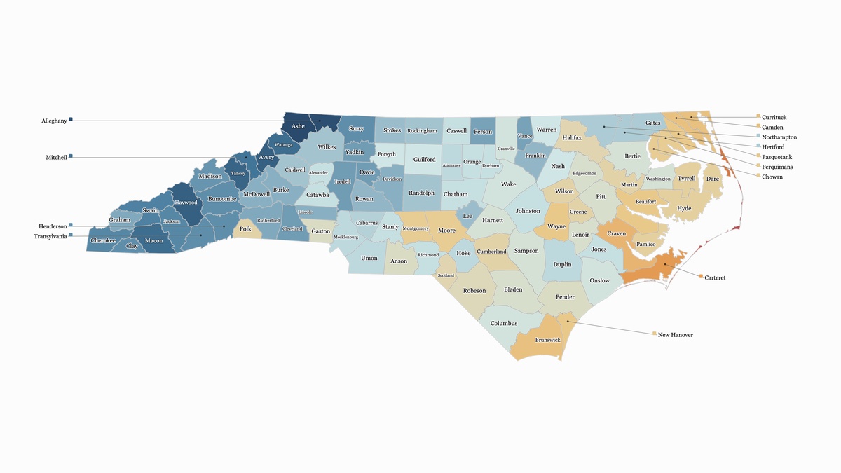
Map of North Carolina’s 100 counties colored by the typical date of the first fall freeze, on a scale from dark blue in early Oct to red in late Dec. The mountain counties are darkest, Ashe and Alleghany first around Oct 10; the Piedmont is pale, around the first week of Nov; the counties along the sounds and Carteret turn gold and orange in mid to late Nov; the Outer Banks are a thin red strip, freezing last in Dec.
Geography · Nov 7, 2026

When Does Your County Get Its First Freeze?

The typical date of the first 32° night of fall in every county, from the mountains in early Oct to the Outer Banks in late Dec
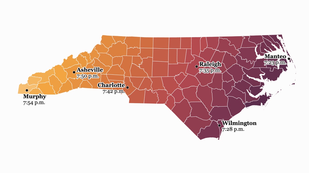
Two maps of North Carolina’s counties. The top one, in blues, shows the latest sunrise of the year if the clock stayed on daylight saving time: after 8 a.m. in every county, from 8:14 a.m. in Manteo to 8:45 a.m. in Murphy, darkest in the mountains. The bottom one, in gold, red and plum, shows the latest sunset of the year if the clock stayed on standard time: before 8 p.m. in every county, from 7:23 p.m. in Manteo to 7:54 p.m. in Murphy, darkest on the coast.Interactive40k views on X
Geography · Nov 1, 2026

Lock the Clock, and Something Has to Give

Sunrise and sunset in every county, any day of the year, under today’s clock, permanent standard time or permanent daylight saving time
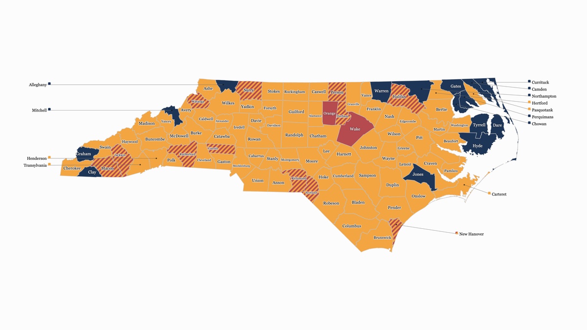
Map of North Carolina’s 100 counties colored by whether each has more Bojangles or more Chick-fil-A restaurants. Most of the state is Bojangles gold; only Wake and Orange are Chick-fil-A red. Twelve counties, including Durham and New Hanover, are striped as ties. Fifteen are navy as dry, with neither chain, most of them in the northeast and the far mountains.103k views on X
Food · Oct 31, 2026

Chicken Biscuit Wars

Bojangles outnumbers Chick-fil-A in 71 of North Carolina’s 100 counties. Chick-fil-A leads in two, and 15 counties are dry, with neither.
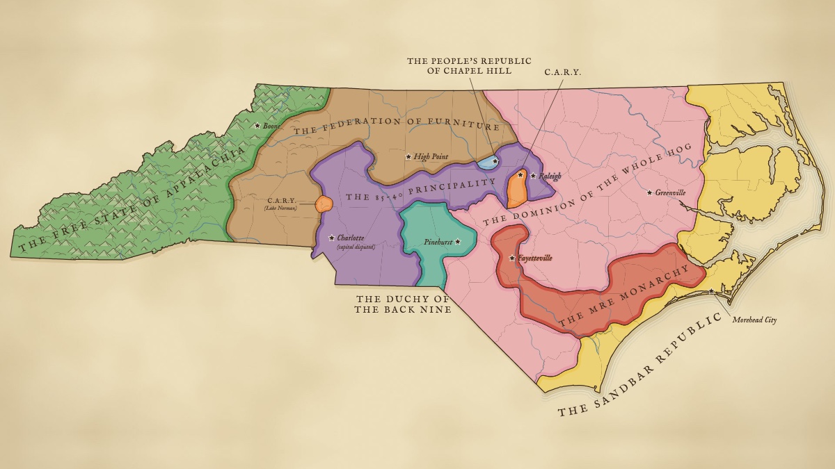
Old-atlas style map of North Carolina divided into nine invented nations, among them the Free State of Appalachia in the mountains, the 85-40 Principality from Charlotte to Raleigh, the Whole Hog Dominion in the east and the Sandbar Republic on the coast.132k views on X
Culture · Oct 24, 2026

The Partition of North Carolina

North Carolina has fallen. Choose your faction.
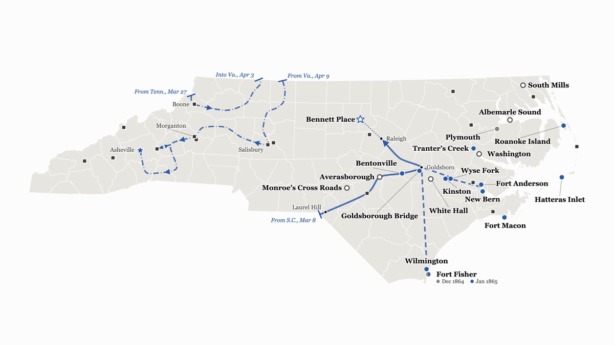
Map of North Carolina with 20 battlefield dots colored by outcome, clustered on the coastal plain, small squares for other fights reaching into the mountains, Sherman’s 1865 march from the S.C. line to Raleigh and Bennett Place, and Stoneman’s looping raid through the west ending at a truce star in Asheville.Interactive38k views on X
History · Oct 17, 2026

Where the Civil War Came to North Carolina

North Carolina’s 20 principal Civil War battlefields, Sherman’s 1865 Carolinas Campaign, and Stoneman’s raid
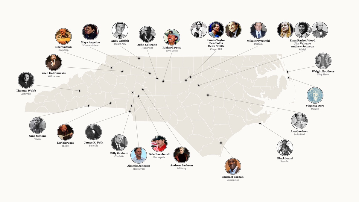
Map of North Carolina ringed by circular portraits of 26 famous North Carolinians, from Michael Jordan and Maya Angelou to the Wright Brothers and Blackbeard, each linked by a thin line to the town where their influence happened.188k views on X
Culture · Oct 10, 2026

North Carolina’s Cultural Titans

From first birth to first flight, the people who made North Carolina.
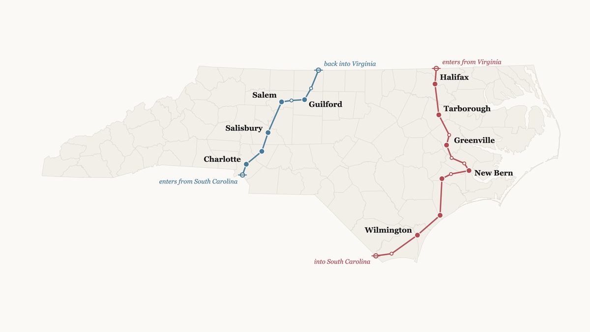
Map of North Carolina showing George Washington’s two 1791 routes: a red southbound line from the Va. line through Halifax, New Bern and Wilmington to S.C., and a blue northbound line from S.C. through Charlotte, Salisbury, Salem and Guilford back into Va.72k views on X
History · Oct 3, 2026

Washington Crossed North Carolina Twice in 1791

Down the coast in the spring, back up the Piedmont weeks later, both from his own diary. He was not impressed.
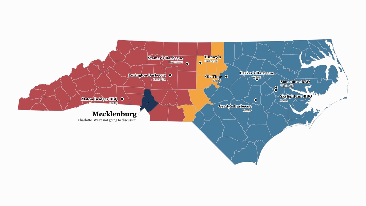
Map of North Carolina counties colored by barbecue style: blue Eastern counties across the coastal plain, red Lexington counties across the Piedmont and mountains, a gold hybrid band between them, Mecklenburg in navy as a joke, and nine dots for well-known barbecue restaurants.351k views on X
Food · Sept 26, 2026

The Definitive NC Barbecue Divide

It's all hog. Just depends on which parts. And if you add tomato to your vinegar or not.
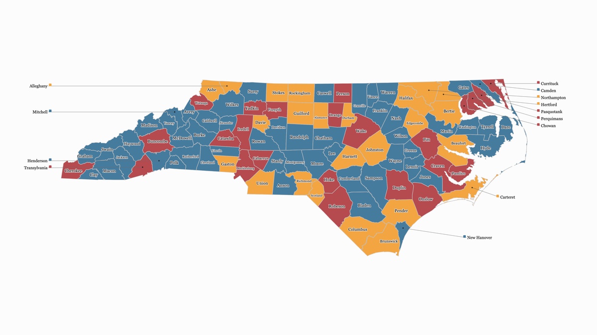
Map of all 100 North Carolina counties, each labeled and colored blue for yes, gold for let’s think about it, or red for no, according to whether the county’s name would work as a baby name.74k views on X
Culture · Sept 19, 2026

Can You Name Your Baby After an NC County?

All 100 North Carolina counties, ranked: yes, let’s think about it, or for the love of bbq and grits, no!